A Spring-Like Round of Thunderstorms Spawned Tornadoes Around Illinois Monday
February 28, 2023 6:01AM CST
Courtesy National Weather Service
- A quick-moving, vigorously deep weather system was responsible for widespread heavy rain and embedded storms, some severe, in northern Illinois and northwest Indiana on Monday morning, February 27. This same storm system produced widespread severe weather in the Plains on Sunday.
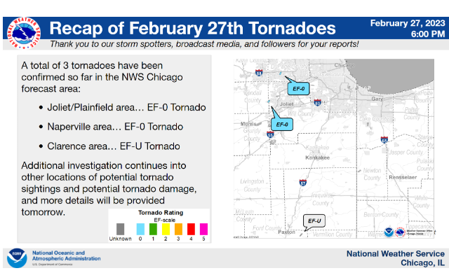
- Through coordination with Emergency Management of damage and trained storm spotters of visual reports, we have been able to confirm three short-lived tornadoes occurred Monday morning, though more may be confirmed on Tuesday as the NWS continues to investigate. (as of 9 P.M. Monday, February 27)
- Two of the tornadoes were EF-0 in damage intensity and occurred for less than a few minutes each in the Chicago suburbs:
- One in the community of Joliet, IL crossing Kendall County into Will County, causing roof, window, and fence damage, as well as damaging multiple trees
- The other in the community of Naperville causing mainly tree damage
- The third tornado in Ford County in east central Illinois occurred near the small town of Clarence and was identified through confirmed photos relayed through broadcast meteorology partners. Emergency management has identified no damage with this tornado (which means it is categorized as an EF-U or EF-Unknown).
- Monday’s event served as a reminder that tornadoes can happen at any time of the year in northern Illinois and northwest Indiana, and that some environments are favorable for them to spin up quickly, such as Monday morning’s setup (strong turning winds in the atmosphere but little warming at the surface).
- Many communities received over one inch of rain Monday morning which resulted in ponding on roads and field and ditch flooding. Rockford received 1.54″ of rain which broke the daily record for February 27 of 1.30″ set in 1948.
- Report from the National Weather Service